The Red Centre, Northern Territory
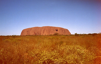
Ayers Rock: Uluru in Kata Tjuta National Park: Northern Territory
(1.2.2003) Stands 348m (1,142ft) high (863m/2,831ft above sea level)
Me and Bryan travelled on the Ghan train from Adelaide to Alice springs and took a two night, three day camping tour of the Northern Territory from Alice Springs. The first day was an early morning start and a 6 hour, 460km drive to Katta Tjuta National Park. We walked up the tough 1.6km ascent to the top of Ayers rock whilst the rest of the group walked around Uluru. A chain handhold is there at the beginning of the climb which is very steep in places. We had to have regular rests and water due to the steep hike to the top in desert conditions. The temperature 30 degrees and it was a long hard slog to the top. After the chain ended we thought we were at the summit but this was only halfway. The rest of the climb was easy with flat areas in the shade. Once at the top we had a warm can of VB and the views were stunning. We could see The Olgas at the distance and the surrounding vegetation. After we descended we wandered around the Aboriginal Cultural Centre and then travelled to the car park to watch the sun going down over Ayers Rock and then camped near Uluru in swag bags under the stars after a good drink.
Ayers Rock at dusk The Olgas: Kata Tjuta National Park (2.2.3003) Woke up early to see sunrise over Uluru feeling very rough. We headed West for a 50 minute drive to the Olgas, named after a Spanish queen by the explorer that discovered this place. The Olgas (Kata Tjuta) are a cluster of 36 steep sided, red rock domes. We took a 3/4 hour hike in the blazing hot sunshine, hiking to the valley of the winds which was a 7.5km loop through clusters of steep, red domes. The weather was very hot and after the hike we drove to the next camp site near Kings Canyon in Watarrka National Park North around 350 km away. The Olgas On the trek to the Valley of the Winds The Valley of the Winds Kings Canyon: Watarrka National Park (3.2.2003) This was a 6km circular hike from the top of the canyon in around 3 to 4 hours. The walls of Kings Canyon are over 300 metres high and part of the gorge is a sacred aboriginal ground. We followed the Kings Canyon Rim Garden of Eden Mount Conner |


